Death Valley: 8 Top Day Hikes to Explore
In: Trail Notes
Death Valley National Park is one of those parks I hesitated to visit for many years. The name Death Valley hardly sounds inviting. Dry hot climate, vast desert, isolated landscapes did not have any appeal to me. I mostly imagined Death Valley to be an arid wasteland, devoid of water and life. After visiting the park for a week, I learned a lot. I explored different trails, learned about the natural history of the park, geology, trees, mammals, birds, and other plants and wildlife of the area. Some of the common questions I had prior to visiting the park are lised below and are documented for my own personal use.
Why is it called Death Valley?
Death Valley was given its forbidding name by a group of pioneers lost here in the winter of 1849-1850. Even though, as far as we know, only one of the group died here, they all assumed that this valley would be their grave. They were rescued by two of their young men, William Lewis Manly and John Rogers, who had learned to be scouts. As the party climbed out of the valley over the Panamint Mountains, one of the men turned, looked back, and said “goodbye, Death Valley.”
Was Death Valley ever under the sea?
Death Valley is below sea level, and as we know it today and has always been separated from the sea by mountains. Death Valley region was formed by seabed for hundreds of millions of years as the abundant layers of limestone, dolomite and marble prove.
How long is Death Valley?
Death Valley is about 140 miles long, from the head of Last Chance Canyon in the north to where the Amargosa River makes its big bend near Saratoga Springs in the south.
Where is the lowest place in the park?
Badwater Basin is the lowest point in North America, with an elevation of 282ft. below sea level and it is a must-stop on any first trip to Death Valley National Park. The area gets less than two inches annually and no water can flow out of the basin. The water gets trapped and evaporates, leaving behind mineral deposits that cover the basin like a salty dusting of snow. The salt flats in Badwater Basin cover nearly 200 square miles, among the largest protected salt flats in the world. Max length for Badwater Basin is 7.5 miles (12km) and Max width is 5.0 miles.
Where is the best place to see sunrise or sunset?
Dante’s View in my opinion is one of the best places to see a gorgeous sunset! Dante’s viewpoint is at an elevation of 1,669 m (5,476 ft) above the sea level, along the crest of the Black Mountains, overlooking Death Valley. The viewpoint offers beautiful views of Badwater Basin, Telescope Peak, and many other beautiful peaks. It is easily accessible, and it gives the best overall views of southern half of the national park. From the roadside overlook, a short path climbs to the actual summit (Dante’s Peak), which has even better views, while nearby Coffin Peak is reachable by a rather longer but still relatively easy off trail hike, and gives an alternative perspective, revealing more of the lands to the south and east. Total distance is up to 1 mile or more (out and back) with an elevation change: 200 feet.
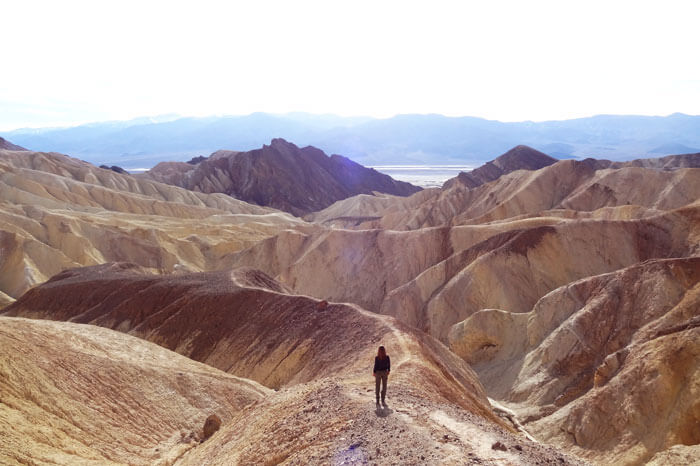
Zabriskie Point is perhaps the most famous Death Valley viewpoint and a spectacular place to experience beautiful sunrise. Zabriskie Point is truly more than a scenery and a famous overlook of colorful ravines and hills at the edge of the Black Mountains. The area is composed of sediments from Furnace Creek Lake, which dried up 5 million years ago—long before Death Valley came into existence.
What are the popular hikes in Death Valley?
1. Golden Canyon – Gower Gulch Loop Trail offers some of the most stunning beautiful red mudstone, colorful mosaic conglomerates and landscapes in Death Valley National Park. The 4.3-mile trail begins with a one-mile trek up Golden Canyon. The route up Golden Canyon is gradually uphill through a rocky corridor of towering golden walls. Numbered markers along the way make the canyon easy to follow.
2. Mesquite Flat Sand Dunes is the most known and easiest place to visit in Death Valley. They are located in central Death Valley near Stovepipe Wells. The Mesquite Flat Sand Dunes are at the northern end of the valley floor and are nearly surrounded by mountains on all sides. Mesquite Flat Sand Dunes are 100ft. (30- meters) high. The primary source of the dune sands is the Cottonwood Mountains which lie to the north and northwest. A small parking lot located off Highway 190 three miles south of Stove Pipe Wells offers a great starting point for a trek out to the dunes. Total miles out and back is 3 miles.
3. Mosaic Canyon is a hike that is out of this world. It is a fine specimen the geology of Death Valley National Park. The trail is 4-mile moderately trafficked out and back, and it is a hike you don’t want to miss. The trail offers beautiful views of water-polished conglomerate rocks that look like mosaic tiles grouted onto the canyon wall. The best water-polished marble in the entire canyon is between 0.21 and 0.27 miles from the trailhead.
4. Salt Creek Interpretive Trail is one of the most places I absolutely loved exploring in Death Valley. There is a stream flowing on the valley floor, more than 200 feet below sea level. Like all desert oases, plants and animals congregate around its life-giving waters. It is home to one of the most amazing small creatures found nowhere in the world. They are called, Salt Creek Pupfish (Cyprinodon salines). They are able to survive 100- degree temperatures and live in a water where water salinity is higher than the ocean. Even more surprising, the rare Salt Creek Pupfish has thrived in its seasonally fluctuating waters for thousands of years, despite all odds.
5.Wildrose Peak Trail (9,064ft.) leads through conifer forests, offering some welcome shade for hiking. The limber and bristlecone pine-studded trail stretches but pays off with impressive views of Death Valley Canyon and Trail Canyon. It is one of the spectacular trails I absolutely enjoyed hiking in the backcountry of Death Valley National Park. The peak is the northernmost summit of the Panamint Mountainsí highest section. The 8.4-mile round-trip trail starts at the north end of the charcoal kilns and climbs steadily up a drainage thick with pinyon pine and juniper. The final two miles of trail meanders along a forested ridge and switchbacks up the peak, revealing increasingly spectacular views. It is a rewarding hike and it is filled with incredible panoramic vistas of the valleys.
6. Telescope Peak (11,331ft.) trail is strenuous and is the highest point in Death Valley. It is 13-mile round-trip hike, and is well worth it! For best views, check, May or June is the best place to explore the trail.
7. Ashford Canyon Trail is rated as difficult. The steep 4.2-mile round-trip hike follows the canyon and pieces of the old mining road. Colorful Ashford Canyon leads to the tucked away and well-preserved Ashford Mine Camp.Gold mining caught on in the area in 1907; the Ashford Mine was worked until the 1940s, when it was finally abandoned, leaving behind cabins, underground rooms, and the trappings of camp life.
8. Sidewinder Canyon Trail is easy. It is 2-4 miles or more to explore different slot canyons, sculpted narrows and natural bridges. The trailhead is south of Badwater Basin off of Badwater Road.
Death Valley National Park Map


you might also like
-
Camping with cats in Lake Tahoe
May 25, 2024
-
Sunrise Hike at Spooner Lake
September 3, 2022
-
Hiking with Pasha
August 26, 2022