Top Day Hikes Along Tioga Pass Road
In: Trail Notes
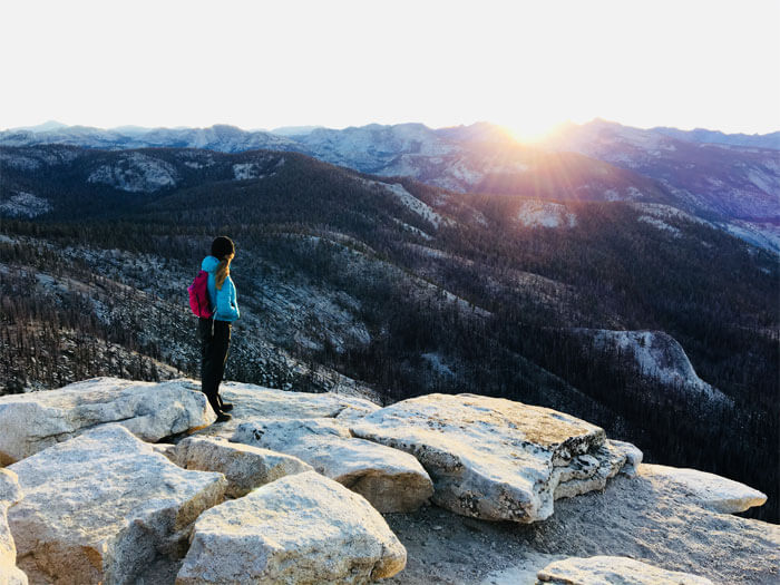
Day hikes and overnight trips along Tioga Pass are abundant with a scenic reward of its own! Trips available from the stretch of the Tioga Road range from relatively level forested hikes to Yosemite Valley’s north rim to trails plummeting deep into Yosemite’s northernmost canyons. No place in the park is diverse, rich and glorious as hikes along Tioga Pass Road. So, what are the top day hikes along Tioga Pass? After exploring more than 100 miles of trails, here is a list of my favorites!
What are the top day hikes along Tioga Pass Road?
1. Clouds Rest is a mountain in Yosemite National Park east-northeast of Yosemite Village, California. Although there are many peaks in the park having far greater elevation, Clouds Rest’s proximity to the valley gives it a very high degree of visual prominence. Clouds Rest is an arête, a thin, almost knife-like, ridge of rock formed when glaciers eroded away solid rock to form Tenaya Canyon and Little Yosemite Valley. The northwest face, mostly solid granite, rises 5,000 feet (1,520 m) above Tenaya Creek. The summit can be reached by a 7.2-mile (11.6 km) trail hike from Tioga Pass Road or a 9.4-mile (15.1 km) trail hike from Happy Isles by way of Little Yosemite Valley.
2. May Lake to Mtn. Hoffman Trail is a hike I highly recommend. The trail to Mount Hoffman is completely unmarked, but well-enough traveled to be fairly easy to follow when the ground is snow-free. To find the trail from May Lake High Sierra Camp simply follow the path next to May Lake as it wraps around the southern edge of the lake, just beyond the backpacker campsites. The overall trip to the top of Hoffman is less than 2 miles from May Lake, but it is a grueling 1,500+ foot climb. As you are approaching the rock scramble to the peak with its large radio tower on top there are two distinct routes. One veers to the left and up some loose scree appearing and disappearing from view as you go (there are parts where there’s no obvious route, you should just pick what you are comfortable with). The alternate route if you follow the rightmost path heads up a steeper, boulder route with less scree near a cliff edge. If you are comfortable hoisting yourself up some big boulders and not too fearful of drop-offs a few feet away, this rightmost route may be preferred, but otherwise, the leftmost route is the way to go. The view is worth the struggle. You’ll feel like you are on top of the world as you peer down on Half Dome a couple of thousand feet beneath you.
3. North Dome Trail via Tioga Road is a 9.3 mile lightly trafficked out and back located near Mariposa, California that features beautiful wildflowers and is rated as difficult. Access in the winter can be obtained by hiking up Snow Creek Trail and then to Indian Rock. Indian Rock is an easy trail and can be accessed from Porcupine Creek trailhead. This is a great hike right off the Tioga Road in Yosemite that takes you through some great meadows, past a rare granite arch called Indian Arch and onto the granite of North Dome.
4. Mtn. Dana Trail is 7 miles out and back and is rated as difficult. Mt. Dana is the second-highest mountain in Yosemite (after Mount Lyell), reaching 13,061 feet tall. The 5 miles out and back hike without a doubt is strenuous and has an elevation gain of 3,000ft. Park your car at the Tioga Pass East Entrance where the trailhead is. There is no sign for this trailhead, but it is close to the parking area. When you reach the top, views of Mono Lake, Dana Plateau, Dana Glacier, and Dana Lakes are stunning!
5. Olmstead Point Trail is only 0.25 miles (0.4km) round-trip with an elevation gain of 100 feet (30 meters). It only takes about 15-30 minutes to complete the entire hike. The is awesome for striking glacial erratic boulders lounging on the hillsides. High for the amount of hiking involved. Looking west, you’ll see a closeup view of Clouds Rest, with Half Dome beyond. Looking east, you’ll see Tenaya Lake and the granite domes that envelop it. And the Olmsted Point parking lot itself is an interesting stop, with its surrounding slopes dotted with glacial erratics.
6. Gaylor Lakes Trail is 2 miles (3.2 km) round-trip with 500-foot elevation gain hike. It takes 2 hours to complete the hike. The trailhead begins at Tioga Pass Entrance Station. The hike offers some of the most spectacular views off of Tioga Road. This route combines both on-trail, cross-country travel, and a walk into history. Near trail’s end is the site of the Great Sierra Mine. In 1881, the Great Sierra Mining Co. hauled tons of machinery to Gaylor Lakes Basin and beyond and proceeded to drill and blast a 1,784-foot-long main tunnel into the mountains behind Upper Gaylor Lake in search for gold and silver. After four futile years of digging, the miners abandoned efforts to uncover the rich vein of silver believed to lie buried deep below this rugged country. A bit beyond Upper Gaylor Lake, there is an old stone cabin, a rather well-built structure with 2-foot-thick rock walls that dates from the 1880s. Other mine ruins are located near the cabin. With so much scenery packed into a short hike, this trail is fairly popular! Get an early start to avoid the crowds.
7. Tenaya Lake is carved out by the Tenaya Glacier that extended from Tuolumne Meadows down to Yosemite Valley during the last ice age, Tenaya Lake is an alpine lake located along Highway 120/Tioga Pass Road along the gateway to Yosemite’s granite-laden high country. Popular with summertime swimmers and paddlers, Tenaya Lake is the largest easily accessible lake in Yosemite. The Tenaya Lake Trail runs along the lake’s southern shore under the shade of lodgepole pine. The relatively short and easy trail connects the scenic vistas and rocky coves of the west end to the broad beach and picnic areas of the lake’s east end. This is an excellent, family-friendly hike. The trail can be accessed from either the main Tenaya Lake parking area on east shore or along the west shore at the Sunrise Lakes/Clouds Rest Trailhead when Highway 120 is open, typically May through November.
8. Mono Pass Trail is 8 miles (12.9 km) round-trip hike with an elevation gain of 1,000-feet. It takes 4-6 hours to complete the hike. The trail begins at Mono Pass Trailhead Parking area, on the Tioga Road six miles east of Tuolumne Meadows (shuttle service is available twice per day). This historic, trans-Sierra trail climbs gently at first from the Mono Pass parking area, through wet meadows and rushing creeks. At the Spillway Lake junction, the trail climbs steadily and more steeply to Mono Pass (elevation 10,600 feet). There are spectacular views of Mono Lake and Bloody Canyon from the pass. Hike a bit farther toward Upper Sardine Lake.


you might also like
-
Sunrise Hike at Spooner Lake
September 3, 2022
-
Hiking with Pasha
August 26, 2022
-
8 Day Hiking Trip to Arches and Canyonlands National Park
June 7, 2022